


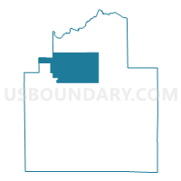
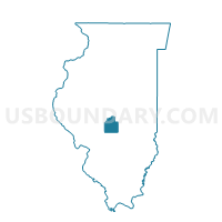
BUCKHART 1 Voting District, Christian County, Illinois
About
Outline

Summary
| Unique Area Identifier | 564848 |
| Name | BUCKHART 1 Voting District |
| County | Christian County |
| State | Illinois |
| Area (square miles) | 58.75 |
| Land Area (square miles) | 58.72 |
| Water Area (square miles) | 0.03 |
| % of Land Area | 99.95 |
| % of Water Area | 0.05 |
| Latitude of the Internal Point | 39.66223970 |
| Longtitude of the Internal Point | -89.33607080 |
Maps

Graphs
Select a template below for downloading or customizing gragh for BUCKHART 1 Voting District, Christian County, Illinois


Neighbors
Neighoring Voting District (by Name) Neighboring Voting District on the Map
- COOPER Voting District, Sangamon County, IL
- COTTON HILL Voting District, Sangamon County, IL
- MAY Voting District, Christian County, IL
- MOSQUITO Voting District, Christian County, IL
- MT AUBURN 1 Voting District, Christian County, IL
- SOUTH FORK 2 Voting District, Christian County, IL
- STONINGTON 1 Voting District, Christian County, IL
- TAYLORVILLE 2 Voting District, Christian County, IL
- TAYLORVILLE 3 Voting District, Christian County, IL
- TAYLORVILLE 4 Voting District, Christian County, IL
Top 10 Neighboring County Subdivision (by Population) Neighboring County Subdivision on the Map
- Taylorville township, Christian County, IL (12,483)
- South Fork township, Christian County, IL (2,788)
- Buckhart township, Christian County, IL (1,792)
- May township, Christian County, IL (1,581)
- Stonington township, Christian County, IL (1,131)
- Mount Auburn township, Christian County, IL (1,028)
- Cotton Hill township, Sangamon County, IL (902)
- Cooper township, Sangamon County, IL (893)
- Mosquito township, Christian County, IL (390)
Top 10 Neighboring Place (by Population) Neighboring Place on the Map
Top 10 Neighboring Unified School District (by Population) Neighboring Unified School District on the Map
- Ball-Chatham Community Unit School District 5, IL (26,649)
- Taylorville Community Unit School District 3, IL (18,866)
- Rochester Community Unit School District 3A, IL (10,434)
- Edinburg Community Unit School District 4, IL (1,973)
Top 10 Neighboring State Legislative District Lower Chamber (by Population) Neighboring State Legislative District Lower Chamber on the Map
- State House District 100, IL (117,164)
- State House District 87, IL (106,764)
- State House District 98, IL (103,277)
Top 10 Neighboring State Legislative District Upper Chamber (by Population) Neighboring State Legislative District Upper Chamber on the Map
- State Senate District 44, IL (225,390)
- State Senate District 50, IL (218,180)
- State Senate District 49, IL (207,061)
Top 10 Neighboring 111th Congressional District (by Population) Neighboring 111th Congressional District on the Map
Top 10 Neighboring Census Tract (by Population) Neighboring Census Tract on the Map
- Census Tract 39.01, Sangamon County, IL (5,102)
- Census Tract 9582, Christian County, IL (3,888)
- Census Tract 39.02, Sangamon County, IL (3,829)
- Census Tract 9581, Christian County, IL (2,999)
- Census Tract 9586, Christian County, IL (2,277)
Top 10 Neighboring 5-Digit ZIP Code Tabulation Area (by Population) Neighboring 5-Digit ZIP Code Tabulation Area on the Map
- 62568, IL (16,355)
- 62563, IL (5,686)
- 62531, IL (1,792)
- 62513, IL (1,766)
- 62567, IL (1,154)
- 62547, IL (804)